Measurement FARO 3D Focus Latest
Latest Focus3D Faro Measurement, Terrestrial Laser ScannerMultiple Applications. Laser scanning technology or LightDetection and ranging (LIDAR) is growing and widely used fordiverse applications. As in the Faro product made by the following.
LIDAR terminology commonly used for measurements with a planeor helicopter mode, while for the car or four-wheeled vehiclescalled Mobile Terrestrial Laser Scanning (MTLS). If the applianceis placed on a tripod, called Stationary Terrestrial Laser Scanning(STLS).
In survey work, civil and mining, technology STLS basicallymeasure the distance with laser technology, as well as using TotalStation measuring devices. The difference, STLS instrument can measure distances up to hundreds of thousands of points per second, known as cloud point.
By placing control points on the area being measured, all the pointcloud can know its position and has the coordinates X, Y and Z as well as measurements using a total station.
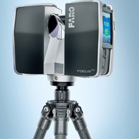
Faro introduces 3D measurement tool called Focus. Unlike otherSTLS, Focus3D already have an internal battery with up to 5 hours of measurement capabilities and features 32 GB of memory tostore data on SD or SDHC card slot.
Use of Focus3D also very easy, because it is equipped with touch screen operating system that is easy to use. In Indonesia, the tool is didistribusukan by PT Datascrip.
Latest Focus3D Faro Measurement, Terrestrial Laser ScannerMultiple Applications. Laser scanning technology or LightDetection and ranging (LIDAR) is growing and widely used fordiverse applications. As in the Faro product made by the following.
LIDAR terminology commonly used for measurements with a planeor helicopter mode, while for the car or four-wheeled vehiclescalled Mobile Terrestrial Laser Scanning (MTLS). If the applianceis placed on a tripod, called Stationary Terrestrial Laser Scanning(STLS).
In survey work, civil and mining, technology STLS basicallymeasure the distance with laser technology, as well as using TotalStation measuring devices. The difference, STLS instrument can measure distances up to hundreds of thousands of points per second, known as cloud point.
By placing control points on the area being measured, all the pointcloud can know its position and has the coordinates X, Y and Z as well as measurements using a total station.
Faro introduces 3D measurement tool called Focus. Unlike otherSTLS, Focus3D already have an internal battery with up to 5 hours of measurement capabilities and features 32 GB of memory tostore data on SD or SDHC card slot.
Use of Focus3D also very easy, because it is equipped with touch screen operating system that is easy to use. In Indonesia, the tool is didistribusukan by PT Datascrip.
0 komentar:
Post a Comment
THANKS FOR YOUR COMMENT.